
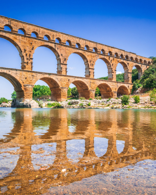
Have you ever stood beneath the Pont du Gard and thought about how it was built? Most people who visit this three-tiered Roman aqueduct in the south of France come away with one reaction: disbelief. It stands nearly 49 metres tall. It stretches 275 metres across the Gardon River. Every stone on the lower two tiers was placed without a drop of mortar — around 50 AD. Nearly 2,000 years later, not a single arch has fallen.
The Pont du Gard is not just a striking ruin. It is one of the best-preserved examples of Roman engineering anywhere in the world, and understanding how it was built makes a visit considerably more rewarding.
Love France? Get our weekly letter.
Stories, tips, and hidden corners of France — delivered to your inbox every week. Subscribe free here.
What the Pont du Gard Actually Was
The Pont du Gard was never built to carry people or carts across the Gardon River. It was built to carry water. Specifically, it formed the tallest section of a 50-kilometre aqueduct that transported fresh water from springs near the town of Uzès to the Roman city of Nemausus — what we now call Nîmes.
Nîmes was a substantial Roman settlement, home to tens of thousands of citizens. The city needed a reliable water supply for its baths, fountains, and private households. The aqueduct delivered roughly 40,000 cubic metres of water every single day — the equivalent of around 16 Olympic swimming pools.
The water channel itself sits on the very top tier of the bridge. It is just 1.8 metres wide and 1.8 metres tall. Water flowed through it by gravity alone, following a gradient so slight that the entire 50-kilometre route drops only 12.6 metres from start to finish. That is a slope of roughly 1 in 3,000 — a level of precision that required Roman surveyors to work with extraordinary accuracy using nothing more than plumb lines, water levels, and measuring rods.
The Scale of the Construction
The bridge is built in three tiers of arches stacked on top of one another. The bottom tier has six arches and spans the full width of the river valley. The middle tier sits directly above it with eleven arches. The top tier, which carries the water channel, is built from 35 smaller arches.
The stone blocks are enormous. The largest weigh up to six tonnes each, and the entire structure uses an estimated 50,000 tonnes of limestone in total. Most of the stone was quarried less than a kilometre away from the building site, which reduced transport time — but thousands of heavy blocks still had to be moved across difficult terrain and raised to considerable heights.
Historians estimate that around 1,000 workers built the Pont du Gard, completing it within three to five years. They used wooden cranes, pulleys, and temporary scaffolding — technology the Romans had refined over centuries of large-scale building projects. The cutting precision is remarkable: on the lower two tiers, the blocks were stacked entirely dry, relying on their weight and careful shaping to hold the structure together without any binding agent.
The Marks the Builders Left Behind
One detail that surprises many visitors is the rows of protruding stones visible on the outer face of the arches. These are not decorative. They are the stubs of the wooden scaffolding poles that held the centering in place during construction — the Romans never trimmed them flush once the work was complete. They remain today as a record of the building process itself.
Look closely at the individual blocks and you will also find numbering carved directly into the stone — a system that helped workers place each block in its correct position during assembly. These small human touches give the bridge an unexpectedly personal quality. Behind the scale and the engineering logic, you can trace the work of real people, cutting and numbering and hoisting stone across a river gorge to a timetable set by engineers whose names history has not preserved.
Love France? Get our weekly letter.
Stories, tips, and hidden corners of France — delivered to your inbox every week. Subscribe free here.
How Long It Has Stood
The aqueduct carried water to Nîmes for roughly 400 to 500 years. After the decline of Roman authority in the region, maintenance fell away and the channel gradually silted up. By the 6th century it had ceased to function as a water supply.
The bridge itself proved almost impossible to destroy. During the Middle Ages, the lower level was adapted into a road crossing, with sections of the arch widened to allow wheeled vehicles to pass. This caused some structural damage, but the bridge survived. In the 18th century, the writer Jean-Jacques Rousseau visited and wrote that it was one of the most astonishing things he had ever seen — and that it made him feel ashamed to have been born in a lesser age.
Napoleon III ordered a major restoration of the bridge in the 19th century. Further conservation work has taken place since, and the Pont du Gard was designated a UNESCO World Heritage Site in 1985. It now draws over a million visitors each year.
What to Know Before You Visit
The Pont du Gard sits in the Gard département of southern France, about 23 kilometres north-east of Nîmes and 26 kilometres west of Avignon. Both cities are well connected by rail, and Avignon in particular is served by TGV high-speed trains from Paris and other major French cities.
There is no direct public transport to the site, so most visitors arrive by car. Car parks are available on both banks of the Gardon River, and entry to the outdoor site is covered by the parking charge rather than a separate ticket. Walking across the bridge is free once you have parked.
The museum on the left bank is worth visiting if you want to understand the full context of the aqueduct system. It covers the route of the 50-kilometre channel, the engineering decisions involved at each stage, and life in Roman Nîmes. Allow roughly two hours for the site if you plan to visit the upper-level viewpoint and explore the museum.
Swimming in the Gardon River beneath the bridge is permitted in designated areas during summer and is popular with families. The water is clear and the views of the aqueduct from the river are excellent. If you are visiting in July or August, arriving before 9am makes a significant difference to how busy the site feels.
The Best Time to Go
April, May, September, and October offer the best combination of warm weather, manageable crowds, and good light. The bridge is orientated roughly east to west, so it catches morning light on one face and late afternoon light on the other — photographers tend to prefer early evening.
July and August are the busiest months. The site is well managed and never feels chaotic, but car park queues can form on summer weekends during peak hours. A visit before 9am or after 5pm in high summer is noticeably more pleasant.
Winter visits are quieter and the bridge is no less impressive in low light. The river level can be higher after autumn rains, which adds to the drama. The site remains open year-round, and on a clear winter morning you can have the bridge almost entirely to yourself.
Practical Details
Address: 400 Route du Pont du Gard, 30210 Vers-Pont-du-Gard, France.
Parking: approximately €18 per vehicle (check pontdugard.fr for current rates).
Nearest railway stations: Nîmes (23 km) and Avignon (26 km).
Getting there: car hire from Nîmes or Avignon is the most practical option.
Official website: pontdugard.fr.
Love France? Get our weekly letter.
Stories, tips, and hidden corners of France — delivered to your inbox every week. Subscribe free here.
Tours & experiences you might love


Powered by Viator. Some links are affiliate links — we may earn a small commission at no extra cost to you.

Leave a Reply